
Part 1 – The Prehistoric
This is the first in a series of articles describing Grayshott’s history up to the beginning of the the 20th century. It’s a very long history because the land upon which Grayshott stands was formed over a hundred million years ago in the Cretaceous Period. The climate was warmer then, sea levels were higher and Grayshott was under a shallow lagoon. Sediment washed in by rivers became compacted to form our Lower Greensand bedrock. Dinosaurs such as ichthyosaurs and plesiosaurs swam in the warm water above, but sadly greensand doesn’t preserve fossils well so you’re unlikely to find one in your garden. However, the monkey puzzle tree in Whitmore Vale Road, opposite the churchyard, would have been a familiar type to huge pelorosaurs grazing on the nearby mainland. Movements of the Earth’s crust eventually pushed Grayshott up into a ridge, now called the Hindhead Anticline. When you travel along the B3002 you follow the eroded hinge of this anticline, the result of tectonic movements thirty million years ago.
The glaciers didn’t reach Grayshott during the last Ice Age. Nevertheless for tens of thousands of years the climate was arctic, the land bound by permafrost and growing only tough grass and moss. Huge mammals such as mammoths, woolly rhinos, cave lion and hyenas wandered the landscape, and very occasionally bands of adventurous human hunters visited from the continent. One of them left a flint tool in Headley. A mammoth’s tooth has been dug up in Godalming, and their tusks in Farnham, but nothing so far in Grayshott.
During the Mesolithic period, from about eleven to six thousand years ago, the climate warmed and the ice retreated. Southern Britain became covered by primary forest of birch, Scots pine and oak. This forest was less dense on the dry, infertile soil of our greensand hills, which created attractive conditions for mobile groups of hunter-gatherers to camp and hunt. Their flint tools have been found all around our area.
Neolithic farmers began to clear the natural forest, although they seem to have preferred the open chalk downs to our greensand. A few tools have been found locally, but it seems that their owners left our ridge as forest in which to hunt, gather and harvest woodland materials.
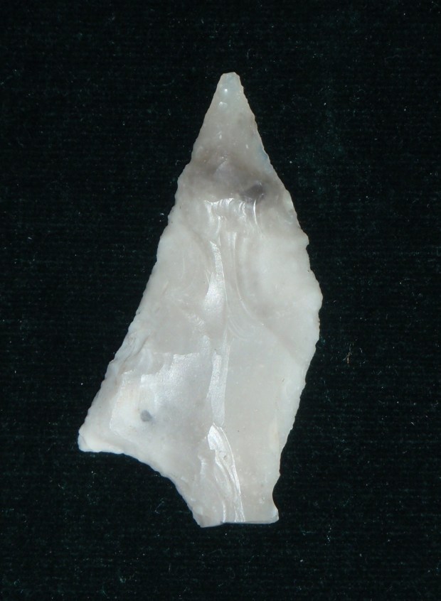
One day, on Ludshott Common, a Neolithic archer missed their target and lost their arrow. Four-and-a-half thousand years later a walker found its beautifully worked flint head on the surface of a path.
Agriculture intensified in the Bronze Age and farms spread up onto the greensand. The heaths around Grayshott originated in this period – the village is built upon land which was worked by farmers a few thousand years ago. Their cultivation caused the thin, dry soils to starve and the land reverted to pasture then rough grazing. The farmers also left their mark in the form of burial mounds in surrounding parishes, including Ludshott Common. A Bronze Age torc – a neck ornament – was found near Grayshott Hall and there are hints of prehistoric activity and perhaps a barrow cemetery towards the top of Waggoners Wells Lane.
Iron Age remains have not yet been found in Grayshott. It’s thought that the high ground was used as summer grazing by villagers from the lowlands. Some of our old roads such as Hammer Lane evolved as driftways for moving livestock up onto the ridge. The northern stump of School Road, opposite the Pottery, is another ancient driftway.
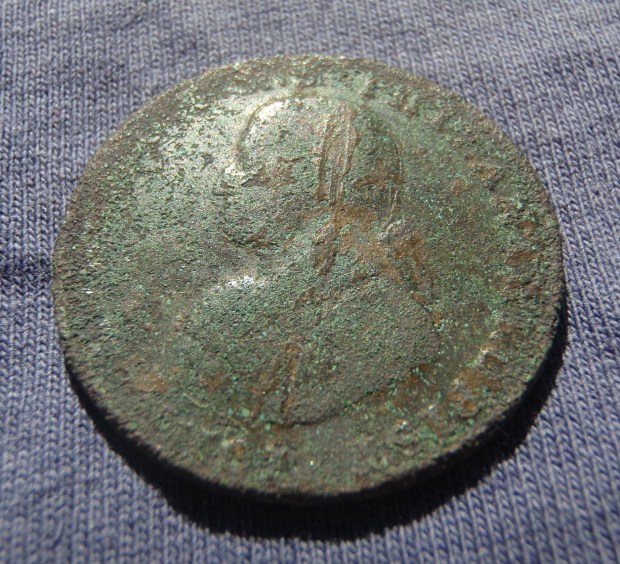
Roman occupation was all around – including a pottery at Alice Holt, a possible cemetery at Tilford and a shrine near Frensham Pond. Roman coins have been found in Grayshott, quite close together, perhaps indicating that they were not just a random loss. No definite evidence of Roman settlement has been found, but maybe so far nobody has looked hard enough in the right place…….

These coins were found in Grayshott. On the left is a silver denarius of emperor Caligula, which was minted before the invasion of 43AD. The sestertius on the right was minted between 161 and 180AD. (Photo courtesy of PAS)
So keep a keen eye when you are walking or gardening – many people were in Grayshott before us and you might be the next lucky one to find their tools, jewellery or coins.
JC – January 2018
Part 2 – The Saxons
It’s difficult to imagine now, but thirteen hundred years ago the little Southwater stream in Whitmore Bottom was the frontier between the two mighty Saxon Kingdoms of Wessex and Mercia. South beyond Hammer Vale was the kingdom of Sussex. For two centuries these kingdoms were in conflict and Grayshott was on the front line. (Our side, Wessex, eventually won.)
After the Romans left, Angles, Saxons and Jutes began to occupy southern Britain. In our area, by about the year 600, Saxons were colonising along the River Wey. Godalming, Eashing, Frensham, Thursley, Lynchmere, Liphook and Headley are all Saxon settlements. Their farmers would have looked up from their new-won fields towards a knobbly, heath-covered ridge that dominated the valleys for miles around. They would have seen, silhouetted on the skyline, a ring-ditch with an earthen bank and hedge or palisade, about half a mile across, a place the surviving Romano-British people called the Saex-Tun-Pen or Saxon Hilltop Farm. The Saxons knew it as Graf Sceat, Grove Corner. We call it Grayshott.
The Saxons were primarily farmers, driven to conquest by population growth in their homeland. They were also warriors; they fought to take land and to keep it, against the Britons and against each other. They understood the strategic value of high ground. The ridge of Grayshott and its spur of Flat Wood offers long views across the Wey valley, from the South Downs in a westerly arc around to the Hog’s Back beyond Farnham. They would not have ignored this natural observation post that looked over their new farms. They would certainly have noticed the eroded driftways where for hundreds or thousands of years the locals had been driving their livestock up to summer pasture.
A possible scenario, derived from the field pattern of medieval Grayshott, is that to occupy this ridge the Saxons made a farmstead in the area of Bulls Farm (the horse paddocks by Hammer Lane). From Bulls – or perhaps then called Bulla’s – a track developed down into Whitmore to the fresh, clear water of the stream. The track crossed the stream at Brydelades Forda – Gushing Stream Ford. Downstream was Baeren Forda, the Woodland Swine Pasture Ford, now Barford. Upstream, at the head of Whitmore Bottom in a spot on the footpath behind the gardens of Hurstmere, was Wulfrede’s Beame – Wulfrede’s Gallows, or Post. Further on, up near the Hindhead National Trust car park, was Wolf Horan – Wolf Ridge. We know these names from the copy of a charter, written in the year 965 but describing an event in 688, when King Caedwalla gifted the Hundred of Farnham to Bishop Haedde of Winchester.
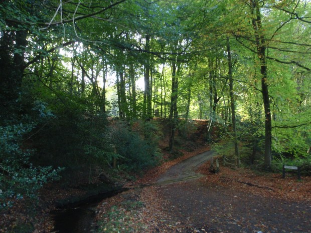
Brydelades Forda, the watersplash in Whitmore Bottom, beyond which the track leads up the side of the hanger into the heart of the old hamlet at Bulls Farm.
No Saxon objects have so far been found in Grayshott, or remains of their houses, which are surprisingly rare. The evidence of their presence is in such placenames. These names preserve the language of the people who lived on the spot, farmers who knew and observed the landscape intimately in all its seasons and depended on it for their livelihood. They named it as they saw it and those names have passed through the ages to us, gradually mutating to the comfort of contemporary ears. Thus the words Saex-Tun-Pen became simplified into Syxtenepenne, which in the 16th century was an area at the top of Superior Camp, exactly where an enclosure would have appeared on the false skyline to a distant observer. The remnants of its actual earthwork are just to the north, around the grounds of Grayshott Spa.
From Bulls the Saxons expanded their fields north up the spur of Flat Wood. The earthworks are still there, on the lip of the hanger, now protecting only against the ghosts of wolves and Mercians, but the names of Denefield (Valley Field) and Raylfeld (Roe Deer Field) haven’t been spoken for centuries. The fields reached south across the land of Grayshott Spa, then continued up the flat plateau towards Waggoners, more properly Wakenors. For the Saxons it was the Wacen Ora – the Watching Place Ridge – that first gave purpose to their presence here.
The Saxons are long at rest in their graves – their fragile remains perhaps under our gardens, woods and fields – but for us their legacy lives on every time we speak the name of our village, Graf Sceat.
JC – February 2018
Part 3 – Medieval Grayshott
We think that the Saxon settlement at Grayshott originated in the Hammer Lane area. By around 1300 the hamlet had become a string of six smallholdings, each of 10 or 20 acres, covering about 100 acres on the land of Bulls, Flat Wood, Grayshott Spa, Applegarth and Waggoners. The fields ran in strips back from the hanger, each 180 yards wide. This distance was the local furlong, a ‘furrow’s length’. The entire hamlet was surrounded by a ditch and bank at least six feet from bottom to top and with a thorn hedge upon it. These banks survive, you can see excellent examples just inside Flat Wood from Hammer Lane. The stump of another crosses the footpath around the edge of Applegarth, and there are more in the Hanger.

This copse by the footpath at Applegarth contains the remains of a medieval boundary bank.
Medieval Grayshott was a cultivated island amidst heath and woods. The lanes in and out were gated, so-called ‘hatches’, the memory of which survives in Hatch Field off Hammer Lane. The community within, about 50 people, was thus protected from n’er-do-wells and wild animals. There certainly were wild animals – there was a wolf pit behind Hurstmere.
Few people lived in the bottoms, the main settlement being on the high ground. During the 13th century however, there were piecemeal encroachments into Whitmore Bottom from the Barford end as increasing population pressure caused people to occupy the marginal land. One such place was Low Leg, Leg being Middle English for a ledge or shelf of land, which was a crofter’s purpresture – an informal clearance from the waste – of which the surrounding bank and ditch still exists as part of a modern property boundary.
Grayshott’s people were unfree tenants of their lord of the manor, the Bishop of Winchester. They rented their land under a set of customary rules, and owed labour service and taxes in return for spiritual and economic protection. They were not allowed to leave the manor for more than a day without permission, they paid tithes on their harvest and taxes upon clearing new land, renting a property, marrying and dying. The bishop was careful to keep records of these taxes. Here are a few examples.
- In 1274, 3/4d was paid by ‘Julia of Graveselate for land conceded by her father’ (a dowry), and another 3/4d by ‘Walter of Graveselate for Julia and her land’. This was possibly Bulls Farm.
- In 1316, 13/4d was paid by ‘Richard of Graveschate for a messuage (house) and 10 acres in Graveschate from Stephen his father which Agnes his mother had in her widowhood.’ This was in the Applegarth area.
- In 1409, Richard son of Robert Northgate was taxed 5/- for ‘a messuage and 5/2d worth of land in Graveshote’. This was in the Grayshott Spa area.
The people lived in small but solid houses; the bishop required each to be of three bays with two courtyards, and roofed with tile. None survive above ground but the locations of some are known. In one of them, a certain Hugh carelessly left his personal seal lying around, to be swept with the household waste into the midden, thereafter carried onto his fields as manure, to be unearthed in 2012. Hugh’s fields were arable – rye for bread, and oats and beans for winter livestock feed. He grazed his animals – pigs, sheep and a cow or two – on the common land by day and brought them in to fold on his fallow field overnight. Productivity was at subsistence level but the soil’s fertility was retained by careful rotation, folding and recycling. Hugh’s family grew herbs and greens in their garden, and gathered berries and nuts from the commons. Each holding had a dew-pond for collecting water.
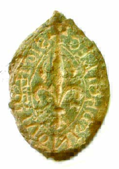
Hugh’s lead seal, lost for eight centuries. (Photo by courtesy of PAS)
The commons of Whitmore, Stoney Bottom, Land of Nod and the area of the modern village were vital for survival. They provided bracken for animal bedding, gorse and peat for burning, coppice wood for construction, grazing for animals and even holly leaves as emergency fodder. You had to be careful not to get caught straying into the next manor; Ludshott manor fined John of Graveshut 3d after he ‘cut and carried away one cart-load of wood and one of bracken from the common pasture of the Lord’s tenants without permission’.
The smallholders were not poor but their lives were of endless toil. A bad harvest meant hunger. Two in a row meant starvation. In 1315 started the Great Famine, a series of crop failures which hastened the end of the sick and old – maybe widow Agnes among them. Then came the Black Death, which hit Grayshott hard. Half its houses were left derelict and the survivors struggling to cope. From the rent rolls: ‘A cottage of Margaret atte Grevesatte which should pay 5/-; 2/- received’. Hugh, Julia, Walter, Richard, Stephen, Agnes, John and Margaret were all real people; their lives were part of the continuity of our village for over a thousand years.
JC – May 2018
Part 4 – Tudor Grayshott
The Tudor period, from 1485 to 1603, held some of the great events that shaped the nation’s character – the English Reformation, the defeat of the Spanish Armada, and the flowering of literature through Shakespeare and Marlowe. From a survey conducted in 1552, and several wills and inventories, we have a detailed picture of our village at this time. It presents a snapshot of an ancient landscape in the process of change.
The medieval farms still existed – Bulles, Kings, Barnelands, Highe Graveshott, Home House and Grasset. At nominal plots of 10 or 20 acres, each being a quarter or half of the medieval land area called a virgate, these were ‘husbandman’ holdings, in effect smallholdings. To step up the social ladder and become a yeoman you would need at least 100 acres.
The nation was slow to recover from medieval famines and plagues; three of Grayshott’s farmhouses were still derelict. One such, Kings, was owned by William Langford who also owned four other farms around Headley totalling 61 acres. This was the big change of the times – the land was becoming owned by fewer people; those with cash could buy out those in trouble. Thus some of Tudor Grayshott’s farms now belonged to bigger holdings, and were worked by paid but landless labourers, and some were still in the hands of medieval-style owner-farmers.
One of the latter was Robert Luckin of Grasset farm, 21½ acres with its house and garden on the site of modern Grayshott Spa. Robert held Grasset ‘in the right of his wife Elizabeth’, meaning it was her marriage dowry. He died in 1572, after ‘committyng hymself to an unskylfull surgion was cutt at Farnham and died and was ther buried’. In life he was something of a rogue, being twice caught stealing timber from the woods of Ludshott Manor, the purpose perhaps revealed by the inventory to his will in which was itemised two loads of timber for spokes, naves and felloes. The smallholders needed more than one source of income, in Robert’s case it was wheelbuilding. The rest of his inventory reveals a lifestyle of modest comfort – flock beds, brass candlesticks, ‘bakon hangyng at the rooffe’….
From such inventories we know that people were growing just enough rye and oats for their own needs. Ordinary people’s food took 75% of its calories from grains, which for our villagers meant rye bread and porridge. Their cash came from sheep, which for centuries had been the source of English wealth, their value being in wool, manure and milk. Mutton was only eaten when the sheep died, and none but the wealthiest ate lamb. Grayshott’s farmers had a quantity of sheep that we might find surprising, Robert for example had 68. They were grazed on the commons by day and folded in the fallow fields by night, where their manure fertilised the soil. On average it took two sheep to maintain the fertility of one acre of arable, and Grayshott’s farmers had enough sheep to achieve this. Each Tudor sheep, much smaller than modern, gave 1-2 pounds of wool, and Robert’s flock would earn him a cash income of a few pounds each year. Out of this he would have to pay his rent at just 5/2d (26p) per year, and employ a shepherd at 6d (2½p) per week plus board.
The fleeces were sold at market in the wool trading towns of Petersfield and Farnham. The old road linking these towns ran right by Grayshott, called Farnham Way, part of it is now the bridleway that runs from Ludshott Common between Grayshott Spa and Dunelm. Other ancient roads were Old Land Lane (now Hammer Lane), Graveshott Lane (the northern stub of School Lane is a fragment) and Bull Lane (the byeway running from Hammer Lane into Whitmore Bottom). The area of the modern village was wood and heath. Through it ran a road called Pytfold Way, which linked the heads of Whitmore and Stoney Bottom across the ridge. It’s route ran up the track now Woodcock Bottom, along Avenue Road by the Co-Op, across the high street, through the car park of Gurkha Durbar and then on through today’s gardens towards Kingswood. In the east, the parish and county boundary was marked by a row of trees – Lez Mark Okes – which ran between Hurstmere and Kingswood along the course of Boundary Road.
There’s also some evidence of industry. Grayshott was on the edge of the Wealden ironworking area, which was a huge consumer of charcoal to fuel the furnaces and forges. Within the Hanger have been found twelve charcoal burning hearths; flat, circular platforms about 20 feet across, shelved into the slope. They’ve not yet been dated – charcoal was made from the Roman times through to the mid-19th century – but at its peak during the Tudor ironworking boom. The Hanger’s coppiced beech and oak fed these hearths, and there are enough of them to perhaps support one extended family of colliers.
Grayshott’s Tudor citizens were not rich but neither were they isolated or backward. Robert Luckin’s trips to market would have brought him into contact with wool traders who a few days before may have shared the latest gossip with merchants in London and Winchester. And a chunk of Elizabeth’s fresh-baked rye bread topped with smoked bacon and a dollop of tangy sheep cheese would have been delicious.
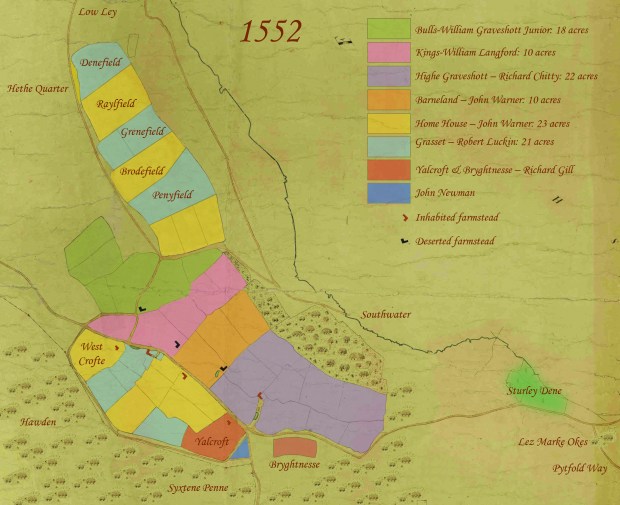
The Tudor Hamlet of Graveshott. Waggoners Bend is between the fields of Yalcroft and Bryghtnesse, Hammer Lane is the track heading towards the top left and Pytfold Way is now called Avenue Road.
JC – September 2018
Part 5 – Georgian Grayshott
The Georgian era, from 1714 to the 1830s, was a time of immense social and technological change. Global trade and mechanised industry created huge wealth, but its unequal distribution intensified class divisions and led to public unrest. For Grayshott, even up on its ridge among the heaths, the march of progress was inevitable.
A Tudor husbandman dropped by time machine into the early 18th century landscape would have recognised it immediately – the enclosed hamlet, its patchwork of small fields, the woods and even the tenants’ rent had barely changed in 200 years. In 1739 William Godson compiled a wonderful map of Ludshott, which shows Grayshott’s southern boundary in pictorial detail. At Waggoners bend the farmhouse of High Graveshott, known as Canes after its tenants, sits behind a gate. Its site is now in the copse behind Baillie Cottage; the footpath is the last memory of its entrance way. Opposite is Home House Farm, the spot’s later name of Burnt House Field reveals its fate. Godson intended the features on his map to be recognised, so these little pictures maybe represent the true appearance of the buildings – modest but solid-looking two-story houses, probably rebuilt upon their medieval foundations.

The Waggoners Bend area in 1739.
The landscape may have looked similar, but the economic amalgamation of smallholdings into larger farms that began in the Tudor period was continuing. By 1766 the old farms of Kings, Barnelands, and part of Bulls were all owned by Richard Holloway of Milford. Canes and Home House were owned by the Mayhew brothers of Herriard. These were absentee landlords, investing in the potential for scientific agriculture to feed a growing town-based population. Richard gave his name to the hanger north of the new Applegarth estate – Holloways Coppice – and the Cane family to that north of Waggoners estate – Canes Coppice. Remarkable as it may seem to us, these precipitous areas of dense, tangled trees were once carefully managed productive woodlands, every 20 acres providing full-time work for one person.
In 1773 the government passed the Inclosures Act, which enabled the enclosure of land and removal of commoners’ access. Although not implemented in Grayshott until 1859, it signposted the beginning of the end for many smallholders, who relied on the commons to supplement their modest plots. It was perhaps no coincidence that the year after, Thomas Gatehouse of Headley Park compiled a rent-roll which listed every tenant, their holding and rent. Gatehouse proudly declared ‘The investigation of these rents which, for want of a regular Roll, had not been collected for many years ….. affords infinite satisfaction to the Bishop and his tenants, and now regulates their yearly payments’. One wonders if the tenants were as infinitely satisfied as the Bishop. Two of Grayshott’s oldest houses survive from this date – Bowes Cottage in Whitmore, on a site many hundreds of years older, and The Old Farmhouse, formerly Bulls.
From 1792 Grayshott was effectively owned by Sir Thomas Miller, who had bought the Wishanger Estate, which included Grayshott. As a moderniser he set about recovering his investment. Around 1800 he planted pines on the exhausted medieval fields of Old Land, the coal mines and Royal Navy being great consumers of timber. As Flat Wood, it remains a plantation today. In 1813 he merged all of the ancient farms except Bulls into one unit, consisting of 113½ acres of arable land, which became known as Grayshott Farm. It was run by a tenant farmer and worked by paid labourers living in tied cottages. This scale of operation enabled greater productivity, but there was a price to be paid by society. The labourers, with no land to fall back on, became entirely dependant upon the landowner for their living, and small farmers were edged out. The result, especially during the agricultural depression following the Napoleonic wars, was chronic poverty for many rural poor.
The effect was felt by Richard Cane. The Canes had been in the parish for centuries, and his parents were once Grayshott’s biggest landowners. When he inherited Bulls Farm of 22 acres he became almost the last independent farmer in Grayshott. During the depression he tried to expand by clearing a new field of 5 acres out of the common. However he couldn’t compete and in 1820 he sold up. He became a labourer on Grayshott Farm.
This halfpenny coinage token from 1794 was found on Richard Cane’s land. As its type was only in circulation for a few years, his was likely the last hand that touched it.
Richard’s successor fared no better; three years later Bulls was again put up for sale – small farmers were struggling. In 1830 long-suppressed resentment bubbled up into riots at Headley and Selborne. Nobody from Grayshott was convicted in the ensuing trials but the villagers must have wondered what sort of future they had to look forward to.…..
JC – November 2018
Part 6 – The Early Victorian Years
At the time of Victoria’s succession in 1837 Grayshott was a totally rural hamlet, untouched by industrialisation. But the community was not stagnant; it was changing dramatically in reaction to economic forces. The ancient hamlet had evolved on the ridgetop as family-sized husbandman farms within an embanked perimeter. Gradually the ownership of land condensed into fewer hands, until by 1813 most holdings had merged to become Grayshott Farm within Sir Thomas Miller’s Wishanger Estate. Agricultural modernisation was happening, but slowly. The older exhausted fields had been planted with fir trees, and new crops such as turnips and clover-ley were adopted, but mechanisation had not arrived. The fields had not yet been enlarged for machines; at two to four acres each, with cut-and-laid hedgerows, they were the legacy of medieval hand-labour.

An extract from the 1846 Tithe Map, showing the multitude of small fields, at this time all arable. Grayshott Farm, now Grayshott Spa, is the L-shaped red building at lower centre. Bulls Farm is in the top left quadrant. Hammer Lane runs from centre to top. At top right is Miller’s fir plantation, formerly the ancient fields of Old Land, now called Flat Wood. It’s eastern edge incorporates the original coppiced woodlands of the hanger, just visible on the map as different symbols and still discernable today by variations in the tree cover.
The consequence of centralisation was two-fold: the ridgetop became depopulated, and previously independent farmers were forced into wage labour. On the ridge, only two houses were now occupied. Bulls, the oldest farm and the only one to remain independent (albeit owned by an absentee) was home to labourer William Lawrence and his wife Matilda. Grayshott Farm was leased to James James of Lurgashall, Sussex, who lived there with his family. James employed two men as farm workers, along with three farmhouse servants. The high ground, which in medieval times had been home to about fifty people, was occupied now by a dozen.
Yet increasing national prosperity was causing population growth. In 1841 Grayshott’s population was surprisingly high, about 60 adults and slightly more children, occupying about 30 households. These people colonised the valleys, places of little conventional economic value. Whitmore Bottom, Stoney Bottom and Waggoners Wells became the cottagers’ settlement areas. Many of Grayshott’s small stone cottages originated at this time, the ‘little low houses’ commented upon by Flora Thompson in her book Heatherley.
For centuries the valleys had been used for rough grazing and woodland but generally ignored for permanent settlement – their waterlogged bottoms and steep sides were just too difficult to work on any scale, and they were outside the protected perimeter. But now the locals, often descended from families that had been in the area for generations, developed a highly localised economy perhaps best described as labourer-smallholder-craftsman-rustler.
Grayshott’s commonest occupation at this time was the ubiquitous agricultural labourer, but the census descriptor of ‘Ag Lab’ simplifies a more complex picture. Many were also smallholders, their plot of half-acre or so being intensively worked, augmented by the ability to graze and gather from the commons and perhaps with a meadow by the stream. The Cane family of Whitmore Bottom is an example of adaptation. In 1820 Richard Cane sold Bulls Farm for £400 and went to work as a labourer, superficially an admission of defeat in desperate times. Yet twenty years later his sons Eli, William and Richard had adjacent new-made plots at a choice spot in Whitmore Bottom which in subsequent decades evolved into market gardens. These plots in the bottom, quite fertile, well-watered, and hand-worked by the labour of an extended family, could produce crops of a higher value than the worn out high fields and gain a cash income from supplying fresh produce to growing urban markets. The impression is that Richard cannily got out of ‘proper’ farming and re-invested his capital in a more profitable family business, one for which his intimate knowledge of the local landscape allowed him to spot an opportunity.
Central Grayshott in 1846. The B3002 is the straight road across; it was made about 10 years before the map. The ancient track of Graveshott Lane runs around the edge of the fields and across the common before descending into Whitmore Bottom by the Crawtes’ holding (centre top, now Bowes Cottage), and then on towards Hindhead. At bottom left is Waggoners Wells with a cluster of broomsquires cottages. The valley of Stoney Bottom heads off to the right, with more clusters of cottages, and joins Pitfold Way. The pond is where the entrance to St Edmunds now is. From this point Crossways Road will eventually be made, heading north-west to intersect the main road where the two other tracks meet, to make our Fiveways.
Many took to crafts, Stoney Bottom becoming the focus of the Hill and Belton families’ broom-making trade, of which Flora Thompson noted ‘piles, built rick-wise, of new heather brooms with shining white newly-peeled handles’. More informal careers were also reputed, the Hampshire & Southampton County Paper reporting in 1854 that ‘Hindhead and Whitmore Bottom are chiefly inhabited by a most lawless set; they frequently carry off three or four sheep in one night and are a terror to the neighbourhood’. Whether true or not, it stands as a reminder that life was harsh for most. Livestock theft was no lark, it was the last refuge of the desperately poor, carrying the death sentence until 1832 and transportation to Australia for many years thereafter.
From an air balloon, the land beneath would have looked idyllic to us – patchwork fields, coppice, hedgerow and woods alive with wildflowers; miles of purple heather; streams in the valleys and emerald meadows beside; thatched cottages with fruit trees and gardens. But that would belie the underlying state of chronic rural poverty. There was no glamour in labour, just gruelling hard work from dawn to dusk, six days a week in all weathers until one became too old and broken down to function. No sick pay, no pension, no security and frequent overcrowding into tiny cottages – the Crawtes of Whitmore being mum, dad, grandad and eight children in one little house. This was the reality for most, and it was about to get worse, for in 1849 was announced the Headley Inclosure, of which more in a following article.
JC – February 2019
Part 7 – The Headley Inclosure
In 1849 the newspapers announced the Headley Inclosure. Rumours would have been circulating the parish for months, but the official words in black and white made the prospect undeniable. The lands affected were Headley Common, Standford Common, Mill Chase Common and Lynford Chase Common. For the hamlet of Grayshott this included the Land of Nod, Whitmoor, Stoney Bottom and Grayshott Common (the modern village). But what was ‘Inclosure’, and what did it mean for Grayshott?
Enclosure was one of the most profound upheavals of rural England, when land subject to communal rights passed into unrestricted individual ownership. The premise was that productivity and prosperity would increase at a greater rate through private enterprise than it could within the traditional arrangements. History has proved the theory correct even if the consequences to communities at the time were dire. Enclosure had been happening for centuries, starting with the rich farmland of open field systems. In 1845 legislation was enacted to speed things up. (Inclosure refers to the Parliamentary Act, enclosure refers to the actual process of dividing and privatising the land.) Before the 1845 Act, land of our commons’ meagre agricultural value would not have justified the cost; the economic trigger was housing development.
The Parliamentary Act set out the ground rules, and Commissioners – yeoman farmers, landed gentry, clergymen – implemented them. They had the power to dictate the form of new holdings, realign roads and set out field boundaries. The principal was that those with a claim on the land were compensated, in cash or by the award of a new plot of land. The rest of the land was sold. A local Valuer was appointed to survey the land; to identify the tenants, their holdings, rents and rights; to assess the value of each and determine their compensation or ‘award’. A complex and emotive process, there was endless scope for undue influence, corruption and vendettas. Headley’s Valuer, John Dawe of Curtis Farm, was dismissed in 1852 for neglect of his duties, and replaced by Edward Hewitt of Winchfield, 20 miles away, perhaps a man less susceptible to local pressures.
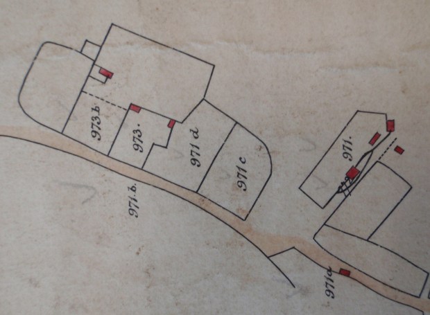
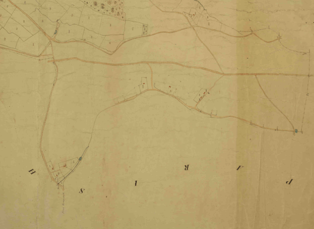
Part of Hewitt’s map, showing cottages in Stoney Bottom. Number 973 was occupied by Henry Robinson; at one time a squatter, he became one of Grayshott’s first shopkeepers.
The Headley Inclosure took ten years overall. It must have been a decade of intense anxiety for cottagers and smallholders. The commons were their free supermarket and DIY store, their source of firewood, turf, peat, bracken, building stone, fruits, nuts and herbs, animal grazing and poached game. In 1853 Edward Hewitt announced that dozens of roads and paths were ‘severally intended to be discontinued and stopped up’. One such was ‘The road or driftway leading from the house of William Lawrence in Whitmoor Bottom, thence crossing the Headley and Godalming Road, thence over common land sold to James Baker, into the public road leading from Whitmoor Bottom to Pitfold, at the cottage and garden of John Lawrence’. Thus ended the ancient road of Pytfold Way, although to be fair new roads were subsequently made and many of the closures seem to have been ignored. James Baker was a speculator from Pitfold. Land in the village centre had been sold to him to pay the costs of enclosure, and the stoppage was obviously to prevent the hoi-polloi from trudging across his investment. The Pines cottages were later built on the plot.
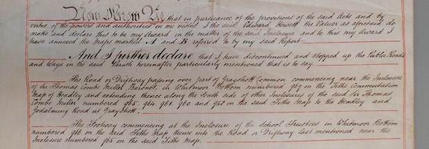
The first entries in the list of stopped up thoroughfares around Grayshott.
In October 1854 Hewitt announced that the new land awards were staked out and ready to enter. Then on 7th December that ‘the Common and other Rights … to be extinguished from and after the fifteenth day of January next’. In practice for a cottager, the award of half an acre or so of their own was no compensation for the removal of traditional rights upon hundreds acres of common. A smallholder economy which depended on symbiosis between field, garden and common was swept away. Some lost everything. ‘Irish Will’, an old man o’war sailor, lived in Whitmoor Bottom and had broken up the land around his cottage for cultivation. Because he’d done this informally – squatted – without sufficient duration of tenancy, he lost his land without compensation. Dinah Jetton, another Whitmoor cottager, said ‘enclosing the common was the first stroke of a famine’. James Winchester was fined for stealing holly, a commodity once freely available.
But there was a balance. Grayshott Common was sold to speculators who built the modern village, including the architect Edward I’Anson. Sir Thomas Combe Miller purchased 248 acres and set up Land of Nod as his hunting estate. Along with Whitmoor it joined his other lands to form the Wishanger Estate, from which the gentrified Grayshott Farm became the country seat of Alexander Ingham Whitaker. Benefactors such as I’Anson and Whitaker gave the growing village its school, playing fields, greens and church. A generation of cottagers had suffered terrible privation, but their children were to find new opportunities with the shops and trades of the growing village.
JC – June 2019
Part 8 – The Country House Economy and Gentrification
After the Inclosure of 1859 private investors built the modern village on the heathland of Grayshott Common. On the old farmland events took a different route, but one which eventually came together with the village to the benefit of both. In the 1770s Sir Thomas Miller MP had purchased Froyle Place near Alton, and soon he was acquiring land in Headley and Grayshott. Through the Inclosure his son and successor, the Reverend Sir Thomas Combe Miller, gained 248 more acres. He combined these lands to form the Wishanger Estate, some 1,800 acres along the left bank of the stream between Grayshott and Frensham Pond.
Sir Thomas jnr was a keen sportsman; his grandson said of him “My grandfather hunted hard to hounds and drank two bottles of port with his dinner. I wonder he wasn’t sick.” He converted his new land, Headley Common, now The Land of Nod, into a hunting estate. He employed a gamekeeper, planted stands of trees, and created ornamental drives. These included an avenue of 300 sweet chestnuts along the Long Gut, and countless more bordering the road to Headley. Hundreds of these survive, now mature specimens, mostly in private gardens but some clearly visible from the public footpath between Hammer Lane and the Heatherlands Estate in Headley Down. The area was called a ‘shooting box’, meaning a small country house with accommodation for the shooting party. Grayshott Farm’s old house was upgraded, to include eight bedrooms and an indoor WC, and re-branded as Grayshott Hall.
In 1868 the estate was sold to John Rouse Phillips, a brewer from Wiltshire, who continued to grandify it. Upon his death in 1882 it was described as ‘a good family residence of modern erection…in the midst of a most excellent shooting country’ with a carriage drive, large lawn, conservatory, billiard room, nine bedrooms, wine cellars, coach house and groom’s quarters. Water was supplied by a ram pump from Whitmore Bottom, the brick house of which is still in the woods. Indoor fittings included ‘Arabian and French bedsteads and….a noble mahogany sideboard’.
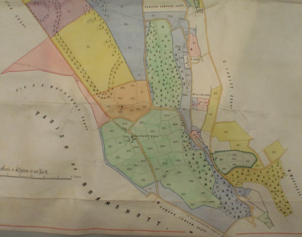
Part of the map from the sale catalogue of Wishanger Estate, dated 21st December 1868. The colour-coded lots were offered separately but Phillips bought everything, keeping the estate whole. The green area at centre and bottom is the former Grayshott Farm, still with agricultural fields but re-invented as Grayshott Hall. Bulls Farm is in orange, extended from its medieval form by some new land granted by the Inclosure. The former Headley Common is in yellow, blue and purple, now a hunting estate, the newly planted tree stands and chestnut avenues can be seen.
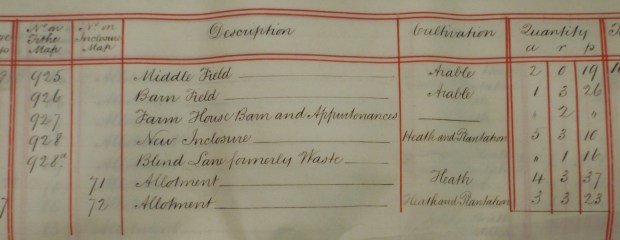
Part of the sale catalogue itemising some of Bulls Farm. The field of New Enclosure was cleared from the heath around 1815-1820. It was poor land, by 1868 was only fit for heath and trees, and was subsequently used by Whitaker as a building plot for some of his new workers’ cottages.
By contrast, the house of Bulls Farm just over the road was home to 13 people – Charles Harris the gamekeeper, his wife and son, and farm labourer William Fifield, his wife Martha and their eight children. So far the effects of enclosure looked distinctly one sided; the local cottagers and smallholders reduced to labourers in overcrowded tenements whilst the gentry made playgrounds out of the old farms and commons.
Things improved from 1883, when the estate was bought by Joseph Whitaker, a wine merchant of Palermo and Yorkshire, as a country seat for his son, Alexander Ingham. Alexander continued expanding the Hall. To make a landscaped garden he broke up the old fields and re-routed the medieval Graveshotte Lane onto the course of our B3002. In the 1890s he converted Bulls Farm into a ‘model’ home farm, to supply produce for the Hall but also to promote his philanthropic and agricultural interests. He built four new pairs of sturdy semi-detached cottages, using high quality materials and pioneering techniques such as cavity walls. They still exist. Every cottage’s front door faced the Hall and into them he installed his workers. By 1911 Bulls Farm was home to 42 people of 9 families, each with their own house. They included the farm trades of cowman, dairy worker, stockman and carter, but also the estate trades of dressmaker, cook, nurse, gardener, carpenter, chauffeur, painter, house boys and a gentleman’s servant. Seven farm children attended the school founded by Catherine I’Anson, wife of one of the first post-enclosure village builders. Alexander became a JP and Lord Lieutenant of Hampshire, a status mirrored by his donations to village projects.
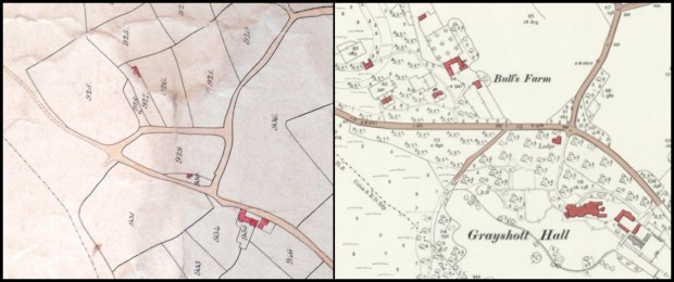
These maps of 1855 and 1909 show the post-enclosure development of Grayshott Hall and Bulls Farm. The stately-home economy meant that dozens of people now had income and security derived from international trade rather than subsistence farming.
The full story of enclosure then – and undeniably it brought terrible privation to a generation of cottagers and destroyed a landscape and lifestyle – is that it brought investment, which in time created new types of work, through which money and opportunity flowed into the village. Grayshott became quite affluent, with its own school, church, doctor, village hall and social clubs.
JC – October 2019
